 Even though this mountain trail is near the prime tourist sites in Toucheng, it isn't very well known. Nor is it particularly beautiful or dramatic. However, this ordinariness is the trail's main charm. Because the trail isn't very popular, it feels more natural than the major tourist trails. It's an extremely convenient way to get into the mountains for a taste of typical Yilan rainforest. It is a short walk from Waiao beach and Wushigang, two of the most popular tourist spots in Yilan. So it's possible to take a walk in the mountains, then go back to the beach and take a dip in the ocean to cool off afterward. There is also an air conditioned coffee shop in the beach visitors center where you can rest and cool off after your hike.
The trail theoretically runs for about two and a half kilometers, but the final kilometer has been paved and made into a rough concrete road which is completely devoid of charm. So the trail is now only about 1.6 kilometers long. Round trip takes about 1 hour 45 minutes. The trail is pretty basic - mostly just a dirt path. In some places you have to climb up or down slippery mossy stones. Given the condition of the trail, you should definitely wear appropriate trekking shoes. You will probably also want to avoid coming here after a heavy rain, as I imagine that it gets very muddy.
As you start to ascend, you will have a superb view of the ocean. Because the mountains are right next to the sea, you can get a fantastic close-up panorama of the ocean, rocky beaches, and  Guishan Island from here. After you get to the top of the first mountain and start going inland, you find yourself in a very quiet subtropical rainforest. The trail runs next to a stream, which is very pretty in spots. Unfortunately some selfish people living downhill have run water pipes through the forest to get free spring water from the source, and these pipes mar the scenery for much of the way.
At the top the trail exits the forest and you find yourself out in the open. If you like you can keep going and walk down the concrete road, but there isn't much to see. The only reason to go forward is to visit a little shrine which dates from the Japanese colonial period, which is located just beyond the forest. Also, the concrete road runs next to a stream which has places where you can bathe in summer. It's a good place to soak in the cold mountain water on a hot afternoon.
The entrance to the trail is easy to find. Directly across the street from the large yellow visitor's center at Waiao beach, north of Toucheng town, is a little road which passes under the railroad tracks. After you go under the tracks you will see two temples. The big temple is called Jietian Gong 接天宮. There is a big brown map of the Shikong trail on the right side of the temple, and  signs in Chinese point the way to the trail head. You can park next to the temples and start walking north next to the tracks, or you can just walk over from the beach. The path along the train tracks which leads to the trail head doesn't look too promising - it becomes very narrow and you will wonder if you've made a mistake. Don't worry - this is the way to get to the trail. When you see a train platform on the other side of the tracks, you will notice some concrete stairs leading upward on your left. A white arrow with red characters marks the trail entrance. Just go up here and keep walking.
 This is a fantastic trek which I recommend very highly. It has everything - gorgeous rain forest scenery and a beautiful river all along a fairly easy trail which is easy to access.
From the parking lot, you cross the little footbridge and start walking up the concrete road into the hills. You have to walk about two kilometers to reach the trailhead, but you pass by a pretty river along the way, so it's not a hardship.
The trail itself is mostly dirt and crushed stone heading uphill at a gentle slope the entire way. At one point you have to cross over a river along a rope bridge, which is fun. And in a couple of places you have to walk over large rocks. The rocks can be kind of slimy, so you should wear good walking shoes.
The point is just to admire the beautiful forest and river scenery. There is an amazing array of plant species here - this is what scientists mean when they talk about biodiversity. In particular, there are lots of birds nest ferns growing on the branches of trees, which are a wonderful sight.
From the parking lot to the top of the trail is a little more than two kilometers. Walking up and back takes about two hours if you keep moving, but I recommend that you take your time and savor the gorgeous scenery. The forest here is incredibly photogenic, so be sure to bring your camera. (I'm lazy so I just take pictures with my iphone - they don't do the scenery justice.) This place is paradise for nature photographers.
The only problem with this place is that it's very popular. The parking lot is huge, which is a bad sign. I visited on a warm Monday in November and I only saw two other people on the trail. But I bet there are a lot of people on weekends during the high season. So if at all possible, visit on a weekday.
To get here, take Road 7 west from Yilan City and drive up into the mountains. You will pass a long bridge over the river, with a nearby gas station. Soon after you will come to the town of Songluo.  The trip from downtown Yilan City to Songluo takes about half an hour. This is an aboriginal area - people here belong to the Atayal tribe, so the trail is marked by a big wooden sign with an aboriginal warrior next to the side of the main road. The access road to the trail is on the left side of the town, next to the big wooden sign. Turn right here and follow the access road down to the parking lot.
After you've walked the trail, if you have the time I recommend you swing by the nearby Cherry Blossom hot spring (see my post) for a bath. Soaking in the hot water feels wonderful after the hike. To get to the hot spring, get back on Road 7 and keep going west (away from Yilan City). After about 5 minutes you will get to a bridge over the river - the Douniu Bridge 鬥牛橋, with a sign pointing the way to Douniu. Cross the bridge and drive for another 5 minutes. The hot spring is marked by a hot pink sign on the right.
 This is the highest and most isolated portion of a network of hiking trails which go along one side of a little valley southwest of Luodong. The first part of the climb isn't all that impressive - there were dump trucks mining the nearby river for gravel, which can be heard from the trail. And there are also some huge pylons supporting electrical transmission lines. But after half an hour, you're beyond the pylons and gravel mining, and inside a tranquil forest. The forest is quite pretty, and I heard some animals stirring around in the bushes in several places, and saw some feces on the trail. If you're lucky you can probably see large mammals here. There are a lot of tung trees 油桐樹 on the mountain, and these bloom in April and May, which is the best time to visit.
The climb up and back takes about 2 hours. The distance is 3.6 kilometers. You're going up pretty much the whole time, to a height of 440 meters, so it's not the easiest trek in Yilan. The path is so so. It varies from just plain dirt to crushed rock held in place with logs. Parts are fine, but other places are a bit rough and some patches need maintenance. The mediocre parts of the trail make the descent a bit slow. If you like, after you reach the peak you can keep going down the mountain on the other side, where the trail eventually connects to the Renshan Botanical Gardens on the other side. (The Botanical Gardens aren't that great.)
This isn't the easiest place to find. To get there, you start from downtown Luodong. Take highway 9 south. After you leave town you will see a brown sign pointing the way to Zhongshan Leisure Farm 中山休閒農場. Turn right at the sign. This road is called Yi 30 (宜 30). You have to turn several times - just follow the brown signs to the Zhongshan Leisure Farm. When you get to the farm, start following the brown signs to the Renshan Botanical Gardens 仁山植物園 or the Renshan Nature Trail. Eventually you will turn onto road Yi 34 (宜 34). This will take you to a large parking lot for buses. This is parking for the Renshan Botanical Gardens 仁山植物園, a tourist trap which sometimes attracts a lot of visitors even though it's not that great. On the road leading to the botanical gardens, there are places to eat if you're hungry.
To get to the hiking trailhead, stay on the road next to the river and drive upstream. The sign marking the turnoff to the trailhead is no longer there - it looks like it blew away in a typhoon. So you have to  keep looking to your left whenever you see a little road leading toward the mountain. A large wooden cone, which can be seen from the riverside road, marks the start of the trail.
There are three ways to get on to the Renshan trail. I took the shortest route, which goes straight up the mountain. There are two other entrances to the trail - you can get there by walking all the way through the botanical gardens, which connects to the trail leading up Renshan, or you can find another trailhead downstream from the botanical gardens. If you start at one of the other entrances, you will be able to walk for a couple of kilometers in the lowlands before starting up the mountain.
 This trail is a short and easy walk up a mountain called Guishan 龜山 (not Guishan island - this is a different Guishan) next to Nanao harbor. Even though you're walking uphill most of the time, it isn't very steep, and the trail is excellent - mostly stairs made from soil and rock held together by large blocks of wood. Because the mountain is next to the sea, there is a spectacular view of the ocean from the top and at various points on the way up.
The only bad thing about this trail is that it only goes for about a kilometer. You can go up and back in about an hour, although will surely want to linger at the top and enjoy the sea view. Considering how remote Nanao is, it really isn't worth coming here just for this trail. You should try to do something else in the area while you're here. However, since Nanao is on the road between Yilan and Hualian, this is the perfect stopover.
I saw lots of mushrooms growing by the side of the trail - many different species. I've never seen so many kinds of weird mushrooms. And next to the train station in town, there was a woman selling  different types of (presumably edible) wild mushrooms. They seem to be a local specialty.
Nanao 南澳 is on the twisty little road between Suao and Hualian. To get there from Hualian, just drive north. From Yilan, take the No. 5 highway south until it ends at Suao. Then follow the signs guiding you toward Hualian. Do NOT follow the signs toward Nanfangao 南方澳. Although Nanao and Nanfangao sound similar, they are in opposite directions. The road toward Hualian is pretty bad - it's just one lane each way, and there are always lots of big gravel trucks driven by insane idiots, so the road is slow, annoying, and dangerous. You're pretty much guaranteed to get stuck behind a slow moving gravel truck, so just relax and enjoy the scenery. The drive from the end of the highway to Nanao will take about 45 minutes. Before you get to Nanao, you will see a set of huge wooden signs on the right directing you toward the Chaoyang trail and other attractions. If you get lost, just head toward Nanao harbor. The start of the trail is well marked, and is right next to the harbor.
Another way to get to Nanao is to take the train. The train station is some distance from the mountain, but there is a shop in front of the station (on the right hand side) which rents out bicycles and scooters. Some bike trails around the mountain and surrounding farmland which have been marked out, and it looks like a nice place for a relaxing ride.
 This is an excellent trail which ascends through a dense rainforest up to a windswept peak about 1000 meters above sea level. Along the way you pass through a variety of micro-climates and see a rich variety of vegetation. Unlike the typical hiking trail in Taiwan, the Marian trail is also a Catholic pilgrimage route. The destination is a large crucifix on a high mountaintop. Although it initially became popular among Catholics, the route is now maintained by the government.
This trail is uphill all the way so you will be quite tired when you finished. If you aren't in decent physical condition, you should try an easier path like the nearby Old Paoma Trail, which is fairly flat. Take plenty of water (more than you think you will need), especially in hot weather. The trail ends on a windswept mountain which can be chilly in summer and freezing cold at other times of year. If you are not doing the hike in summer, bring some warm clothing to wear at the peak. And watch out for snakes and hornets. Several signs warn visitors to beware of poisonous snakes, and sure enough I saw a green bamboo viper (青竹絲) slithering across the trail.
The main drawback to this hiking trail is that it is some distance from the nearest road. To get to the start of the trail you have to walk for almost an hour or more. However, you start from the Wufengqi Waterfalls park, which allows you to kill two (or more) birds with one stone. You can see the falls, walk the Marian trail, and also enjoy the swimming area and riverside park downstream from Wufengqi. And since the trail is so far from the roads, it gives you a chance to get deep into the mountains and experience some unspoiled scenery. Although the trail takes time to reach, it is still fairly popular because it is so beautiful. Even on weekdays there you will encounter a number of fellow treckers.
To get to the trailhead, you can either take the scenic route or else save time by a shortcut through the Wufengqi park. The official path toward the trail starts at the Wufengqi parking lot next to the river downstream from the falls. Walk upstream from the parking lot. The path goes past a pretty riverside park which is extremely popular among families - kids love catching minnows in the shallow water here. Continue upstream and past the swimming area. The trail crosses over a bridge and then continues up a dirt road. After passing along a series of switchbacks up the mountain, you will eventually come to an unusual round Catholic church modeled after the Temple of Heaven in Beijing.
To get to the church more quickly, just park as close as possible to the falls, walk past the food and souvenir stands and up toward the falls. Below the second waterfall is a path to the left which goes toward the third waterfall. Instead of ascending to the third waterfall, just keep going straight - this path keeps going along the side of the mountain and right toward the church.
Whichever way you get to the church, once you are there you follow the road which runs to the left of the church complex and up the mountain. Above the church is a nice view of Jiaoxi and the ocean. Follow this road (made of dirt and rocks) until you get to the trailhead.
If you take the long route all the way from the parking lot, it will take 70 or 80 minutes to reach the start of the trail. The shortcut through the waterfall area will get you there in about 50 minutes.
The Marian trail itself is a little more than 1.6 kilometers long and takes about two hours (or more) to walk up and down - depending on how fast you go. The trail is decent quality - dirt and crushed stone reinforced with logs for most of the way, with stone steps in steep spots. If you don't want to tackle the whole thing, the first 400 meters of the trail are particularly beautiful. This section runs through dense subtropical rainforest beside a rocky stream.
After leaving the stream the trail ascends steeply trough the forest. Unfortunately it ends in an anticlimax. The area at the top has been "developed" by Catholics into a place of prayer. This involved building an extremely ugly concrete pond, and rough concrete steps up to an uneven platform with a crucifix on the peak. There is a forlorn little hostel to the side which is used by groups of Catholic visitors who arrange in advance to stay the night. The overall effect is pretty hideous.
 However, when there isn't too much fog, the view from the crucifix platform is amazing. You can see all the way down to the ocean, with a spectacular view of almost the entire Lanyang plain all the way down past Suao. In the other direction, there is a strange landscape of high grassy mountains which extends into the distance toward Taipei county. This is surely one of the most spectacular vistas in Taiwan.
 This is one of the most famous trekking trails in Yilan.There are always some people on the trail, but you don't have to worry about crowds. The trail is an old Qing dynasty road which used to be the main route into northern Yilan county. The trail runs from the town of Dali 大理 in Yilan county, through the mountains, and down to a riverside park a few kilometers above Fulong 福隆 beach in Taipei county. The two towns are connected by railroad, so it's very convenient to make a circuit. It is also very accessible from Taipei by train, and makes an excellent day trip for anyone who wants to get out of the city and enjoy nature.
There is just one problem with this trail - the trailhead on the Fulong side is several kilometers from the train station, and there isn't any reliable public transportation. So if you come out on this side, you have to walk down the mountain beside a busy road. For this reason, you should definitely start on the Fulong side and finish up at Dali.
I suggest you start the trip by taking the train to Fulong. This is easy to reach from either Taipei or Yilan. If you want, you can go to the beach at Fulong, or else rent bicycles and explore the area. There are several kilometers of cycling paths around the town.
 When you are ready to start walking, you can get a taxi in front of the train station and go to the trailhead. This is in a pleasant riverside park. If you like, you can go down to the river and go for a swim. The cool water feels wonderful on a hot day, and some stretches of the park are really beautiful.
When you're ready, just start walking up the trail. The path is made from large flat stones and is well maintained. At first you will pass through some fields with water buffalo. Then a humid rainforest. The stones get slippery here, so be careful. The trail slopes gently uphill for the first 2/3 of the route. It's not very difficult. You will pass two old inscribed stone tablets, which are major tourist attractions.
There are lots of bilingual signs along the way explaining historical facts and introducing the flora and fauna, and maps along the way showing how far along the route you have come.
Eventually the forest thins out and you are walking through a grassy mountain landscape. During the descent down into Yilan, there are spectacular views of the ocean and Lanyang plain.
At the Dali end of the trail there is a visitor's center complete with coffee shop, so you can sit down in the air conditioning and relax with a cappucino if you feel like a taste of civilization. From here you can walk down to the main road, turn right, and walk a hundred meters or so down to the train station to get home.
 The official name of this road is Yilan Route 1 宜一線. It's a great way to get you deep into the mountains for a scenic drive. The road quickly rises above the ocean and heads west toward Taipei county. It isn't very well known, so this is also a good way to avoid traffic and crowds.
The only challenge is finding the road. First you need to drive along the main road heading north of Toucheng to Daxi 大溪 . This is home to Honeymoon Bay, the surfing beach. After you pass the Daxi train station, you will eventually come to a bridge over a little river. Just before you get to the bridge is an old bronze bust of Chiang Kai-shek on a pedestal by the side of the road. Go up the road behind the bust. This passes through a little community of houses and quickly ascends into the mountains. You just keep driving along this road as long as you want. If you keep going, it will take you into Taipei county.
Above Daxi are some hiking trails which can be accessed from the road. If you're interested you can park and go for a walk. Otherwise there isn't anything in particular to do. There are a couple of Buddhist temples and farm houses along the way but not much else. The point is to just enjoy the  beautiful mountain scenery and cool clean air.
After 40 minutes you will come to Hudiao Lake 虎貂潭. You can't see the lake from the road, but you will see a police station, then a white tiled building with a parking lot. You can park here and take a walk down to the lake and along the river. The walking trail is extremely well constructed - it's almost too good. The path seems like something you would find in a suburban garden. The riverside scenery here is extremely beautiful. You can swim in the shallower sections of the river, although swimming is (theoretically) prohibited in the deeper parts and the lake. Taiwanese assume that people will instantly drown if the water is more than knee deep. Unlike most swimming spots in the mountains, the water isn't freezing cold because it passes through a series of lakes that warm it up a bit. This makes it very comfortable for swimming.
If you keep driving about ten minutes beyond the lake area,  you will come to a pavillion with a view of the sea along the north coast. From here you can keep going down into Taipei county, or else turn back.
 This is one of the best mountain trails in Yilan. There are actually four trails that meet in Taoyuan Valley 桃源谷. Each one is quite different. The so-called Daxi branch of the trail begins at a spot just north of the town of Daxi 大溪, not far from the Honeymoon Bay surfing beach. The trailhead is just 800 meters north of the Daxi train station, so you can easily get here by train from Taipei. (Just make sure you go to the right Daxi and don't end up in Taoyuan county.)
The trail is easy to find. There is a large parking lot at the bottom marked by a conspicuous brown sign. In fact the entire trail is very well constructed and maintained. It is lined with large paving stones the whole way, and occasionally you will come across a stone bench or pavillion. Several large maps along the way will let you know where you are, and milestones mark the distance along the trail. There are even restrooms. It's impossible to get lost - you just follow the stone path onward and upward.
This trail is moderately challenging, so you shouldn't attempt it unless you're in decent shape. You don't have to be an athlete to finish it, but it's 10 kilometers round trip and you're walking up steep stone steps much of the way, so you'll be really tired when you're finished. The trail takes at least 4 hours round trip - longer if you linger or you're a slow walker.
 Nevertheless, this trail is well worth the effort. Along the way you pass through a series of varied landscapes and microclimates. At the bottom the vegetation is sub tropical rainforest. Then you pass through low mountain vegetation with great views of the sea and Guishan Island. After that you enter the mountains, and there are impressive green mountain vistas on either side. Then you pass through a series of lush fern forests. Finally you find yourself in an idyllic alpine landscape at the top. The highest point is about 550 meters above sea level.
Besides being a living encyclopedia of Yilan flora (including lots of wild rhododendrons and some strange mushrooms), there is also some fascinating animal life - besides the usual butterflies, lizards and birds, I also saw a beautiful green snake and two muntjacs.
 The first 45 minutes of the trail are the hardest. You're climbing up steep stone steps almost the whole time. After you reach the top of the first peak, you walk up and down along mountain ridges the rest of the way, so it's much easier going. At points the trail goes through extremely humid rainforest where the stones are covered with very slippery moss. Be careful! In these places it's a good idea to avoid the mossy stones and just walk on the dirt beside the trail.
If you're a glutton for punishment, there is an undeveloped dirt trail which runs beside the main stone path. As you walk up the stone steps at the beginning, you will eventually see an unmarked trail to the right leading off into the woods. This is an alternate trail for those who want to walk along the forest floor.
You will come across some stone barriers as you approach the end. These keep feral water buffalo from wandering down the mountain. The buffalo aren't domesticated, so be careful. Keep your distance and don't startle them.
 Follow the trail until the stone path comes to an end. Here you will find yourself in an amazing alpine meadow, lazily observed by some grazing water buffalo. This is the crest of a ridge above Taoyuan Valley. It's hard to believe you're right above a subtropical rainforest - the scene seems more like Switzerland than Taiwan.
The Daxi trail meets the Caoling branch of the Taoyuan trail here. If you want a longer walk, you can keep going along the Caoling branch. A round trip back to Daxi would be 18 kilometers and would take all day. Alternatively, you could follow the Caoling branch of the Taoyuan Valley trail to the Old Caoling Trail and then either walk down the other trail to Fulong or back down into another part of Yilan.
Because this trail is more challenging than most, unless you happen to run across a hiking club you don't have to worry about crowds. I went on a weekday and didn't come across a single person.
The temperature at the top is much cooler than the bottom. I climbed up on a hot August day, and it was surprisingly cool and misty at the top. If you go any time of the year but summer, be prepared for cold conditions on the peak - you will need warm clothes. And since this is a 10 kilometer walk, be sure to bring lots of drinking water.
 The name of this place is misleading. Even though it's called Da Jiaoxi ("Big Jiaoxi"), it's not in Jiaoxi township. In fact this area is just south of Jiaoxi, over the border in Yuanshan,closer to the town of Zhenshan 枕山. Da Jiaoxi is a pretty valley covered with fruit orchards, mostly guava trees. There are some guest houses and other facilities for tourists. People come here for a scenic drive down the little country road through the middle of the valley,
The road you want is Yilan Road 13. First you need to go to the town of Zhenshan 枕山 northwest of Yilan City. Unfortunately, the start of Road 13 isn't well marked. One way to find it is to look for the big temple in the middle of town. Road 13 begins on the left side of the temple. You can also look for signs pointing the way to Huideng High School 惠燈高中, a private school on this road.
Once you're on Road 13, just keep driving and enjoy the pretty scenery. You might want to stop and buy something from the vendors by the side of the road. Of course you should buy some guavas. You can also buy homemade country-style preserved foods such as kumquats pickled in heavy syrup and femented black beans.
There are a couple of places to have a cup of coffee or tea where you can sit outside and enjoy the bucolic scenery.
There are several things to do on this road. The first stop can be reached by going down the road  to the left of Hushan Elementary School 湖山國小. This takes you to a pleasant little lake called Wanglongpi 望龍埤, also known as Ruanpi 軟埤. You can either walk around the lake or else have a drink at the little cafe.
Head back to the elementary school. On the right side of the school is a little trail marked by a sign which reads "tiaofu budao" 挑夫步道. This trail leads up the mountain. Although well constructed, when I visited it had been mostly reclaimed by the forest. You can still walk to the top if you want to spend 15 minutes pushing your way through weeds. But it isn't worth the trouble. If the trail has been cleared, however, this would be a good chance to take a short walk through the forest. .
The final stop is at the end of the Road 13. Continue down the road, over the bridge, and follow the  road as it veers to the left. You will see lots of signs pointing the way to a guesthouse called Left Bank (Zuo'an 左岸). Just beyond the guesthouse is a swimming spot where people go to splash around in the mountain stream. There isn't any shade here and the water isn't deep, so I wouldn't recommend stopping here unless it's a cloudy day or you have a big beach umbrella. But if you're prepared and just want to enjoy the beautiful natural setting, it's a nice place to spend the day. Since the water is shallow, it's a safe spot to bring small children.
 This trail is an absolute gem. It passes through an unusual and very beautiful ecosystem - a subtropical fern forest. I visited on a weekend, and was afraid that it would be crowded. When I was driving to the trail, I passed through the town of Sanxing nearby, where tourists were lined up to buy scallion pancakes and fried meat (burou 卜肉), which are famous local specialties. Considering the crowds below, I was expecting the trail to be packed with daytrippers from Taipei. Fortunately, I was surprised to find the trail completely empty. Even on a weekend when crowds had descended on the town just a few minutes away, this amazing trail was completely deserted.
Few Taiwanese have even heard of this place. The government probably doesn't promote this trail because the area is obviously very ecologically sensitive and they don't want to attract tour buses. Because this wonderful place is so low key, it has been reserved for the select few who are willing to search for it.
 The trail isn't very long - just a 1.3 kilometer loop around the hill. You can do it in 45 minutes, although you'll probably want to linger and enjoy this special place. This forest seems more like Middle Earth than Taiwan, filled with many unusual ferns, moss, and irridescent blue dragonflies.
The trail is very well layed out. Instead of the usual stone slabs and concrete, the path surface is made from logs, wood chips, and crushed rock. The natural materials of the trail bring you even closer to nature. Bilingual signs point you in the right direction. There are several lookout points designed to allow you to enjoy the view - one east to Luodong and the sea, one north overlooking the river and mountains, and another inside the forest to admire an ancient banyan tree.
There aren't any signs pointing the way to the trailhead. To get there, you take Road Number 7 west from Yilan. Follow the brown signs pointing toward Taipingshan. After leaving the suburbs of Yilan you will eventually come to a long bridge next to a gas station, marked by a sign pointing the way to Sanxing 三星. Turn left and cross the bridge. On the other side of the bridge, the road soon dead ends. Turn left. Then take the first right onto Road 7B (7丙) - there are some vendors selling snacks at this intersection. You will soon see a huge wooden sculpture of a fist by the side of the road. This marks the entrance to trail.
After walking the trail, you might want to stop by the town of Sanxing for a snack - which is the main goal of most Taiwanese tourists who come to this area. Sanxing is famous for its scallion pancakes, which are a bit different from those in the night markets in Taipei. They're thicker, smaller, contain more scallion, and are deep fried. I wasn't too impressed, but you might as well try one while you're here so you can tell people you ate one. There are also vendors selling the local produce (scallions, pears, dragon fruits, etc.) Taiwanese friends will be impressed if you give them some scallions from Sanxing.
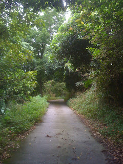 This mountain walk follows the access road to the Lingfeng Chan Temple. You park where the temple's narrow private road meets the two-lane public road, then start walking. The temple isn't much - I chatted with the caretaker, and she said that it's just her (during the daytime) and the monk. She said that they don't get many visitors, so this walk is really off the beaten path. Not many Taiwanese have even heard of this place. Although the more famous scenic walks in Yilan are prettier, this road is extremely quiet. It's a good choice for the weekend when the famous scenic spots have lots of day trippers from Taipei.
The road is paved, and the slope isn't too bad, so it's an easy walk up the mountain. Lining the road is dense rainforest. I saw several unusual birds, including a flock of formosan magpies, so this is a good place for bird watching. I also noticed some monkey feces. If you're lucky you might see a monkey.
Although mosquitoes aren't usually a problem in Yilan, I encountered an angry swarm on the way up. It might be worthwhile to bring some mosquito repellant.
After you walk for about half an hour, you will see a large rock with the temple's name witten on it. Keep following the road uphill, which is now lined with plastic statues of Guanyin.

At the top, in front of the temple, is your reward - a postcard perfect view of Yilan, including Yilan city, rice paddies, mountains, the ocean, and Guishan Island. This is surely one of the finest views in Taiwan.
You can continue up the mountain by first going back down the road for a few minutes, past the plastic statues to the large rock with the temple's name. Another narrow paved road to the right continues uphill. This road isn't nearly as pretty as the walk below. However, the view at the top is even better.
After half an hour walk you will come to a large clearing. The paved road ends here. Continue uphill on the road made of crushed rocks. This road goes up to cemetary at the top. Just below the cemetary you have an even more spectacular view of Yilan far below.If you don't feel like walking uphill and just want the views, you can drive up the temple road to the top. If you go by car, you might want to pray to the Buddha that you don't encounter another vehicle along the way. The road is so narrow that turning around would be almost impossible. To get to the temple, you need a map or GPS. Or you can just start driving and be willing to ask directions. The road toward the temple goes past Longtan (the scenic lake). Go to the left of the lake area and toward the mountains. The road along the way goes through some pretty agricultural areas. Along the way you will see signs pointing the way to the temple.
 This is one of the most popular mountain trails in Yilan. During the nineteenth century it was one of the main thoroughfares between Taipei and the east coast. Pioneers and merchants walked this trail to get to and from the Lanyang Plain. Now the trail is maintained by the government, not just because of its historical significance but also due to the great scenery. Even on weekdays you will run into several people walking the trail. On weekends there can be quite a few visitors.
Although you are climbing the whole time, the slope is gradual with no stone steps and the trail is very well maintained, so it's an easy walk. The trail surface alternates between dirt and gravel with flat stones.
As you walk up the mountain path, in places the foliage opens up to reveal spectacular views across the Yilan Plain to the Pacific. Higher up you have a postcard perfect view of Guishan Island.
 The trail cuts through the mountain forest. Along the way you can hear the water from Houdong Falls far below. Near the top of the trail the foliage gradually changes from lowland subtropical rainforest to evergreens and bamboo. Lots of monkeys live in these mountains, and if you're lucky you might see some. I saw two the day I visited. If you notice a rustle in the tops of the trees, stop and take a look. You almost always hear monkeys before you see them. Also, along the way is a little shrine to the mountain gods, which is a good example of the makeshift spirit of Taiwanese folk religion.
Near the top of the trail is a little mountain spring called Houdongkeng Stream 猴洞坑溪, which feeds the Houdong Falls below. If you climb over some rocks, you will find several little pools which are hidden from view. There you can strip down in privacy and cool off in the icy mountan water, which feels great on a hot day.
 There are two entrances to the trail - one at the bottom (south) near Jiaoxi and the other in the mountains (north) at the top. Almost everyone walks from Jiaoxi uphill, as the south entrance is much easier to get to, and you also get to walk downhill for the last half. The entire walk takes less than two hours.
To get to the trail head, take the road out of Jiaoxi toward Wufengqi Falls and the Royal Jiaoxi Hotel. Turn at the first road on the right - there is a sign here marking this as the road to the Old Paoma Trail. There is usually someone selling snacks at this intersection. (If you get as far as the Royal Jiaoxi Hotel, turn around and go back - you've gone much too far.) Follow this twisting narrow paved road uphill until you get to a large wooden sign that marks the start of the trail. There is room for parking here. Walk along the trail until you get to the paved road at the top, then just turn around and go back down the same way.
 Even though this mountain trail is near the prime tourist sites in Toucheng, it isn't very well known. Nor is it particularly beautiful or dramatic. However, this ordinariness is the trail's main charm. Because the trail isn't very popular, it feels more natural than the major tourist trails. It's an extremely convenient way to get into the mountains for a taste of typical Yilan rainforest. It is a short walk from Waiao beach and Wushigang, two of the most popular tourist spots in Yilan. So it's possible to take a walk in the mountains, then go back to the beach and take a dip in the ocean to cool off afterward. There is also an air conditioned coffee shop in the beach visitors center where you can rest and cool off after your hike.
 Guishan Island from here. After you get to the top of the first mountain and start going inland, you find yourself in a very quiet subtropical rainforest. The trail runs next to a stream, which is very pretty in spots. Unfortunately some selfish people living downhill have run water pipes through the forest to get free spring water from the source, and these pipes mar the scenery for much of the way.
 signs in Chinese point the way to the trail head. You can park next to the temples and start walking north next to the tracks, or you can just walk over from the beach. The path along the train tracks which leads to the trail head doesn't look too promising - it becomes very narrow and you will wonder if you've made a mistake. Don't worry - this is the way to get to the trail. When you see a train platform on the other side of the tracks, you will notice some concrete stairs leading upward on your left. A white arrow with red characters marks the trail entrance. Just go up here and keep walking.


